


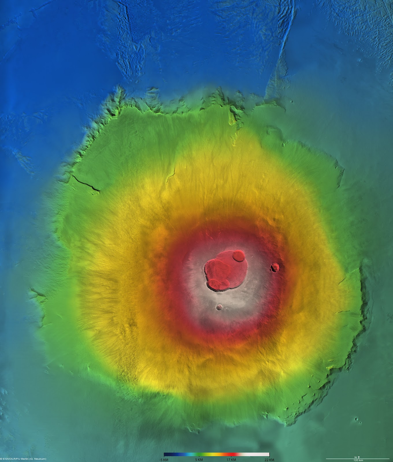
I've been trying to recreate some of the locations on Mars for a short personal project, and I've been endlessly frustrated with the fact that most of the topography maps available online look like this...
https://lh3.ggpht.com/-d2Ei4kKx2sQ/T5m4 ... xpress.jpg
...with the ridiculous rainbow colors denoting the elevations. AFAIK, the only maps that will work in SI for displacement are maps like this:
http://www.solarviews.com/raw/mars/marscyl2.jpg
I've searched for days, and I haven't been able to find the answer, is there any way to convert the crazy rainbow into something SI can actually use, or can I use the crazy rainbow directly in softimage for displacement (and if so, how?).
Thanks!!
Crazy rainbow map to displacement map, help!
-
fm.illuminatus
- Posts: 14
- Joined: 03 Mar 2013, 12:16
-
Falam
Re: Crazy rainbow map to displacement map, help!
You could convert the color image to a b&w image, adjust in Ps. Or you can sculpt in a sculpt package (mud,zbrush etc) then bake out your displacement.

Re: Crazy rainbow map to displacement map, help!
You can try copy each color (color range selection use high values)to a layer make all of them gray (the selection area) . And elevate afterewards with brightness manually analogical to the diagram of colors, gray= ground zero white = 28km etc.
Use lighter color filter , to the layers above 0, and the oposite for those bellow.Do all that on top of a grey bg get rid of the colorfull image. and ull get something ~ ~ sort of ""good"".
This image is not rdy to use even if it was supported, dont expect miracles. mount olympus is 28km beast litle shadows in craters cracks etc, lighs on lower areas bumps ,. can result to huuuge needlez and deep holes.. in the midle of nowhere..
-
fm.illuminatus
- Posts: 14
- Joined: 03 Mar 2013, 12:16
Re: Crazy rainbow map to displacement map, help!
Fortunately, I'm not working with that Olympus Mons image specifically [it was just an example of the type of image I was talking about], I have a few better ones for different areas with less stark shadowing. However, besides shadowing, getting each color to line up smoothly in Photoshop has been a challenge. I was just hoping there was a program, some kind of algorithm, or some kind of plugin that would do better than my butchered Photoshop job...mc_axe wrote:You can try copy each color (color range selection use high values)to a layer make all of them gray (the selection area) . And elevate afterewards with brightness manually analogical to the diagram of colors, gray= ground zero white = 28km etc.
Use lighter color filter , to the layers above 0, and the oposite for those bellow.Do all that on top of a grey bg get rid of the colorfull image. and ull get something ~ ~ sort of ""good"".
This image is not rdy to use even if it was supported, dont expect miracles. mount olympus is 28km beast litle shadows in craters cracks etc, lighs on lower areas bumps ,. can result to huuuge needlez and deep holes.. in the midle of nowhere..
-
SpookyMunky
- Posts: 102
- Joined: 14 Jun 2012, 02:30
Re: Crazy rainbow map to displacement map, help!
cant you just use the images color ranges to set grayscale values in render tree ?, use mixers to layer them.. so basically blue would be black @ 0, green 0.25 , yellow 0.5, red 0.75, white 1 ? shoved correctly into mixers you *should* be ok 
edit: as a side note the color maps nasa use are purely to get the highest possible range of values from any image, something a gayscale will never be able to do really.. yes its just a value from 0-1 nasa wanted from the image but lol, grayscale would limit them to 1/4 of the amount of range they can get from any compression format ?.. bandwidth to mars aint cheap, why waste it sticking to silly black and white
edit: as a side note the color maps nasa use are purely to get the highest possible range of values from any image, something a gayscale will never be able to do really.. yes its just a value from 0-1 nasa wanted from the image but lol, grayscale would limit them to 1/4 of the amount of range they can get from any compression format ?.. bandwidth to mars aint cheap, why waste it sticking to silly black and white
-
fm.illuminatus
- Posts: 14
- Joined: 03 Mar 2013, 12:16
Re: Crazy rainbow map to displacement map, help!
No idea how to do this. ^SpookyMunky wrote:cant you just use the images color ranges to set grayscale values in render tree ?, use mixers to layer them.. so basically blue would be black @ 0, green 0.25 , yellow 0.5, red 0.75, white 1 ? shoved correctly into mixers you *should* be ok
On a related now, how's NASA and all these organizations making 3D models of Mars without B/W displacement maps? There must be some software that uses the color maps or they are converting to B/W maps somehow...
Re: Crazy rainbow map to displacement map, help!
hey dude i made a litle research about those rainbow elevation maps and they are pretty widespread famous and common to earth topographers.
Those maps are called DEM`s and esp for US, there is super detailed maps accesible to the puplic for any area.
About the convertion: There is alot of forums and guys asking this question:
"how to convert dem maps to grayscale"
Check out convertations like this one , maybe u can get a convertion they give some software links too.
http://www.georeference.org/forum/t62323
-
SpookyMunky
- Posts: 102
- Joined: 14 Jun 2012, 02:30
Re: Crazy rainbow map to displacement map, help!
as far as I understand it (which could be very wrong) is they are still just aiming for a 0-1 / black and white depth , but by seperating out the levels to different colours they are getting 4x the actual black-white range of tones than they would otherwise get.. kinda like the equivelant from changing an 8bit grayscale into 32bit... but ofcos even if they recieve the image at 32bit, using every colour will still give them 4x the amount of fidelity compared to just using the black-white chan.. they aren't dumb
how to convert it back into usable data I dunno really, never tried hehe.. in my mind its just a case of singling out each colour bandwidth into a greyscale range thenadd them together with screen maybe ?.. that or there is prolly a photoshop action for it hehe, just remember in ps to set the image depth to 32bit so you can try and keep some of the data that has come all the way from mars !
how to convert it back into usable data I dunno really, never tried hehe.. in my mind its just a case of singling out each colour bandwidth into a greyscale range thenadd them together with screen maybe ?.. that or there is prolly a photoshop action for it hehe, just remember in ps to set the image depth to 32bit so you can try and keep some of the data that has come all the way from mars !

Re: Crazy rainbow map to displacement map, help!
The DEM can't be reconstructed from these shadowy/rainbow colored renders without losing a lot of information.
You could try in Photoshop converting to a Lab color format and removing the b (Brightness) layer, so you have the color only. But converting that result to height is tricky too, you'd probably have to write custom code to map the rainbow colors back to grey, also you'd lose most of the detail compared to the original DEM
http://hirise.lpl.arizona.edu/dtm/ <- this has some unprocessed DEM (DTM) files
Only real option is probably to use global mapper demo to convert the DT*... files from there (the unshaded ones) to some readable format
softimage resources section updated Jan 5th 2024
-
fm.illuminatus
- Posts: 14
- Joined: 03 Mar 2013, 12:16
Re: Crazy rainbow map to displacement map, help!
The problem is, I don't have a 'signed DEM', those aren't available for Mars, AFAIK. All I can get are color elevation maps which would need to be converted some other way.mc_axe wrote:hey dude i made a litle research about those rainbow elevation maps and they are pretty widespread famous and common to earth topographers.
Those maps are called DEM`s and esp for US, there is super detailed maps accesible to the puplic for any area.
About the convertion: There is alot of forums and guys asking this question:
"how to convert dem maps to grayscale"
Check out convertations like this one , maybe u can get a convertion they give some software links too.
http://www.georeference.org/forum/t62323
-
SpookyMunky
- Posts: 102
- Joined: 14 Jun 2012, 02:30
Re: Crazy rainbow map to displacement map, help!
why I thought itd be best to do it in render tree, though if the maps that you have to work with are 8bit per chan increasing the color depth to 32bit and converting to grayscale you shouldn't lose detail in my mind. you are quadrupling the color information per chan then quartering it to one chan.. should be the same hehe. save as hdr, shove into xsi
edit: if they are 32bit then definately do the conversion in render tree hehe otherwise you will lose 3/4 of the height data ... though saying that mray will prolly consolodate the merged result into 32bit colorspace ?
edit: if they are 32bit then definately do the conversion in render tree hehe otherwise you will lose 3/4 of the height data
Who is online
Users browsing this forum: No registered users and 11 guests